


The Brownway Property
Photo Credit: Craig Line
The Brownway property is a 28-acre forest bordering the Missisquoi River in Enosburg Falls. A hiking trail runs through the property, connecting it to the Missisquoi Valley Rail Trail, and Enosburg Falls Elementary School regularly uses the path to lead story walks with students. It is also an access point to the Missisquoi River, providing a primitive campsite for paddlers, including those completing the Northern Forest Canoe Trail. The property is in the village, open to the public, and easily accessible to residents, but it has not always been the forested community resource that it is today. Starting in 2003, a great deal of time, money, and effort went into converting the land from field to forest and wetland.
The Land
In 2003 Jean and Abraham Brown approached a local forester, Nancy Patch, about converting their 28-acre property back to forest. They were leasing it to a local farmer, but the Browns envisioned it acting as a community property- the land had a rich history and was once used as a communal grazing area. It had been ditched and drained to be used as a hay field, but Nancy saw potential to convert sections back to wetland, planting trees on the rest of the land.
It Takes a Village
The Enosburg Conservation Commission took over the grant writing process to get funding for the project. Over the next three years, 7,000 trees were planted, amassing over 1,000 hours of volunteer labor. Two wetlands were also re-established on the property. The project involved multiple partners and funding sources:
-
The Partners Program with US Fish and Wildlife funded the wetlands restoration, installing ditch plugs to establish the natural water level. The water is now able to sheet out over the land rather than draining as it did before.
-
Natural Resource Conservation Service (NRCS) contributed money for trees to plant in the floodplain section, including species such as black willow, shrub willow, nannyberry, and silver maple. The Partners Program with US Fish and Wildlife contributed additional funding for trees and tree tubes to protect newly planted stems. Trees planted in the upland part of the land include cottonwood, red oak, elm, and sugar maple.
-
The National Fish and Wildlife Foundation and Brown Family funded ice deflectors, which protected the newly planted trees from river ice in the winter. Because of the way the Missisquoi River curved at the site, the bottom field would otherwise have been covered with ice. The deflectors were made of salvaged materials, including railroad ties and water pipes.
-
The Missisquoi River Basin Association (MRBA) coordinated volunteers to plant trees every spring for three years, from 2003-2005. On the first day of planting alone volunteers planted 2,000 trees.
The Brownway Property Today
The Brown Family still owns the property and encourages the public to use it for paddling, picnicking, walking, and other recreation. After the restoration work, they conserved the property with Vermont Land Trust, placing an easement on it that would prevent future development. Starting in the summer of 2018 the Enosburg Conservation Commission, with funding from The Upper Missisquoi and Trout Rivers Wild and Scenic Committee, established a free public kayak and canoe rental. The boats are stored on the Brownway property for the public to take out on the river.
The land has become a forest, and the wetlands attract many animals including Virginia rails, bitterns, eagles, osprey, and otters. The trees provide shade to the river, while helping to mitigate runoff and reduce erosion. Overall the project has provided an incredible natural community close to the center of Enosburg Falls, and the MRBA is thrilled to have helped aid in the success of the Brownway Property.
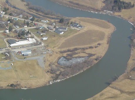
The Brownway property in 2006
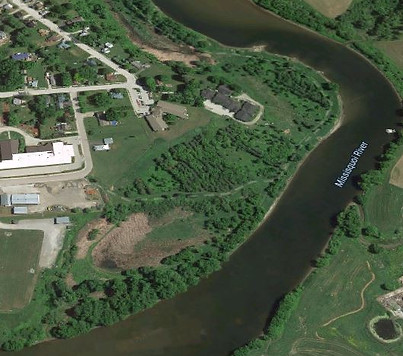
The Brownway property today
photo credit: VT Department of Environmental Conservation

MRBA volunteers getting ready to plant trees in the early 2000's
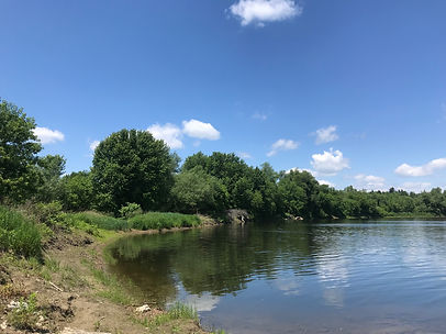
A view of the forested riverbank in 2019
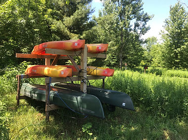
Boats available for the public to use

This story was produced with the generous support of the Lake Champlain Basin Program and the New England Interstate Water Pollution Control Commission
This project was funded by an agreement LC00A00394 awarded by the Environmental Protection Agency to the New England Interstate Water Pollution Control Commission in partnership with the Lake Champlain Basin Program. NEIWPCC manages LCBP’s personnel, contract, grant, and budget tasks and provides input on the program’s activities through a partnership with the LCBP Steering Committee.
Although the information in this document has been funded wholly or in part by the United States Environmental Protection agency under agreement LC00A00394 to NEIWPCC, it has not undergone the Agency’s publications review process and therefore, may not necessarily reflect the views of the Agency and no official endorsement should be inferred. The viewpoints expressed here do not necessarily represent those of NEIWPCC, the LCBP Steering Committee, or EPA, nor does mention of trade names, commercial products, or causes constitute endorsement or recommendation for use.